

Available for Adoption!Contact
|
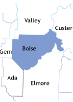
Welcome to Boise County!
Boise County is an original county, established February 4, 1864, with its county seat at Idaho City. It is the parent county to Ada, Washington, Adams, Payette, Canyon, Gem and parts of Valley Counties. Ada County, where Boise City is located, was the first to be split off later in 1864.
Named for the Boise River, from the French word meaning "wooded;" fur trappers were in what is now known as Boise County as early as 1824.
"Gold was discovered in the Boise Basin in 1862, and it was one of the richest gold mining districts in the nation. Its wealth helped develop the state politically and economically. Sawmills operated in the county in 1864, and after the mining boom subsided, lumber became an important industry. . . Idaho City at its peak in the 1860's abd 1870's had about 10,000 inhabitants and was for a time largest city in the northwest. . . Agriculture exists in some of the valleys, particularly at Horseshoe Bend and Garden Valley." - Idaho Almanac, 1977.
The first post office in this part of the state was established at Placerville in 1863.
Boundary Changes
22 December 1864: Ada County created from a portion of Boise County
20 February 1879: Washington County created from a portion of Boise County
15 March 1915: Gem County created from portions of Boise County and Canyon County
26 February 1917: Valley County created from a portion of Boise County
Boise County as we know it today is largely mountainous timber, cut by the Payette River in the west and the north and the Boise River in the south. Over eighty percent of the county is public land. It is within Boise National Forest, with ranger district offices at Idaho City and Lowman.
Boise County 1940 US Census , includes index, maps, and images
Towns and Communities
Idaho City (county seat) Garden Valley, Crouch & Lowman Horseshoe Bend Placerville

|
|||
| search engine by freefind |
Updated August 18 2025
I am Sharon McConnel, your temporary county coordinator.

|
 |
 |

Copyright 1996-2024 The USGenWeb Project, IDGenWeb, Boise County