The Brownlee Trail
"The expected rush to Boise Basin in the fall of 1862 materialized, and the camps of Pioneer, Centerville, Placerville, Buena Vista, and Bannock City (later Idaho City) were established. Thousands of miners, packers, gamblers, and merchants begain to arrive, following the route which came in from the west. This main route was the old Indian trail 'used by the Umatillas and other Indians of Oregon' to reach the council grounds on the Weiser River. Known to whites as the Brownlee Trail, it came down out of Oregon through the hills of the Grande Ronde Valley and crossed the Snake River at the Brownlee Ferry, following the road blazed by the Goodale train the year before. After passing through the southern boundary of the Weiser country, it followed the Payette River as far as Horseshoe Bend before heading up Harris Creek into the Boise Basin." - (p. 35) Hank Corless, "The Weiser Indians/Shoshoni Peacemakers." Caxton Printers, Caldwell, Idaho, 1996.
Eagle Eye of the Northern Shoshone
Eagle Eye, Last Chief of the Tukudia.
Tukudika, Indians of the Wilderness
"Goodale North" Oregon Trail Variant in depth
Nellie Ireton Mills writes - "Indians, trappers and prospectors followed the eastern extenstion of this trail from the Weiser River up Crane Creek, thence over a pass in the hills to Squaw Creek, about fifteen miles above present Ola. From Ola it crossed Little Squaw Creek, followed up Soldier Creek, then over Timbered Butte to Brownlee Creek and down to the ford on the Payette, a few miles above Horseshoe Bend. On the Soldier Creek side of Timbered Butte, the Indians had a natural ammunition depository - a ledge of flint perfect for arrows - probably one reason for the trail passing that way." (p. 32) Nellie Ireton Mills, "All Along the River." Payette Radio Limited, Montreal, Canada.
The Early Wagon Road, about 1882
"The early wagon road into Long Valley was via Squaw Creek, Sweet, and Brownlee, over Dry Buck Summit into High Valley, and on to Smith's Ferry, Round Valley, and Clear Creek. The road and ferry were built about 1882, when the need for ties for construction of the Oregon Short Line initiated the first export of logging products from the upper Payette River. Before the Oregon Short Line built the Idaho Northern Branch railway to McCall (opened in 1915), a four-horse-team stagecoach was operated between Emmett and Van Wyck, carrying passengers, mail, and supplies." - "History of Boise National Forest 1905-1976"
Dry Buck Valley and Dry Buck Creek
Reed's Sawmill, Dry Buck, and Reed Bros. Logging Crew
Original GLO survey showing the location of the Reed & Williams Sawmill and Basey's Sawmill as well as Indian Charley's place -
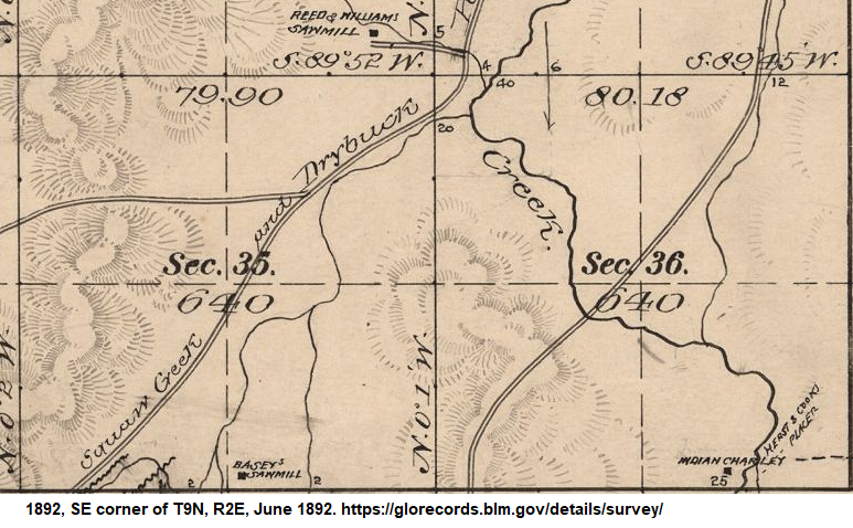
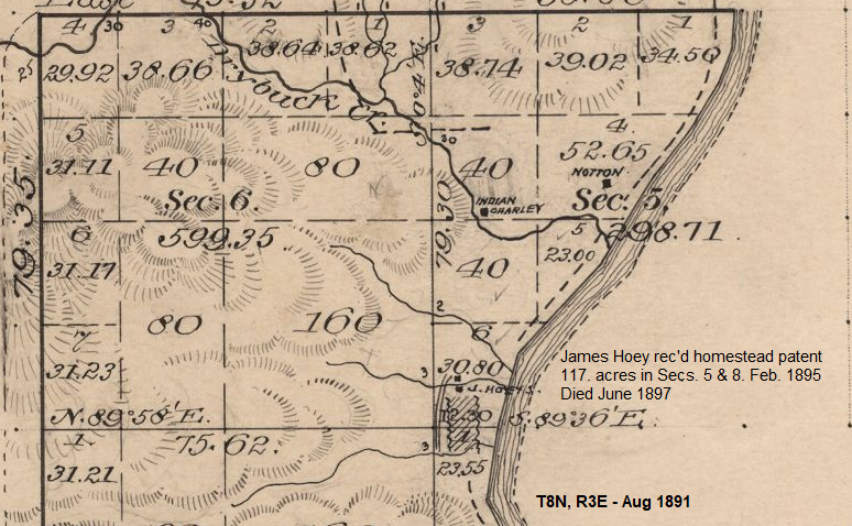
Following Dry Buck Creek southeast downstream two or three miles to the Payette River and James Hoey's homestead, which Mills calls the "Indian Camp. - "At an early date, Jimmy Hoy1, an Irish trapper, and a friend built cabins on the west side of the river on a flat at the mouth of Dry Buck Creek, about a mile below the confluence of the north and south forks of the Payette. Here they were soon joined by a band of abouth thirty Indians. They had been banished from the Lemhi tribe for some tribal offense, after Old Charley, their leader, and his son each had an eye put out in punishment, and had wandered through the hills until they found this haven." Corless writes: "Indian Charley, a Nez Perce member of the Weiser group, should not be confused with Eagle Eye2, who is a Shoshoni and an entirely seperate individual, though it is thought they were related by marriage - 'Idaho Statesman,' April 5, 1898."
Pinehurst Church at Dry Buck
In western Boise County, on Dry Buck - the road forks a little north of here, with the north road going into High Valley (Valley County) and the east road going down to Banks, on the Payette River. The old school was northeast of the junction. The community of Brownlee is to the south, at another fork in the road -- with the west branch going to Sweet, Gem County, and the east branch going to Gardena. This would have been on the route into Thunder Mountain, Valley County. There was a post office in this area from 1903 to 1918. At least once postmistress, Ursula Moore, carried a few groceries.
Brownlee School

|
 |
 |

Copyright © 1996 - IDGenWeb, Boise County. All Rights Reserved.